


Via Ferrata Yves Pollet Villard

Patricelecerf
User
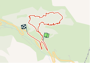

Length
6.3 km

Max alt
1867 m

Uphill gradient
503 m
Km-Effort
13.2 km

Min alt
1326 m

Downhill gradient
566 m
Boucle
No
Creation date :
2017-11-30 00:00:00.0
Updated on :
2017-11-30 00:00:00.0
4h19
Difficulty : Medium

FREE GPS app for hiking
 SityTrail
IGN / Geographical institutes
SityTrail Plus
The world is yours!
About
Trail Via ferrata of 6.3 km to be discovered at Auvergne-Rhône-Alpes, Upper Savoy, La Clusaz. This trail is proposed by Patricelecerf.
Description
13.07.17
Positioning
Country:
France
Region :
Auvergne-Rhône-Alpes
Department/Province :
Upper Savoy
Municipality :
La Clusaz
Location:
Unknown
Start:(Dec)
Start:(UTM)
302224 ; 5083737 (32T) N.
Comments